Let the summit webcam choose. If Pico do Areeiro is clear at dawn, go east: the high peaks and the bare red peninsula at the tip make the best single day on the island. If the top is in cloud, go west, where the coast gives you swimming, cliffs and sunny villages whatever the mountains are doing. Given three days or more, you get both.
In short
- West: sea cliffs, terraced villages, levada walks at Rabaçal, the lava pools at Porto Moniz, the sunniest coast. Good in most weather.
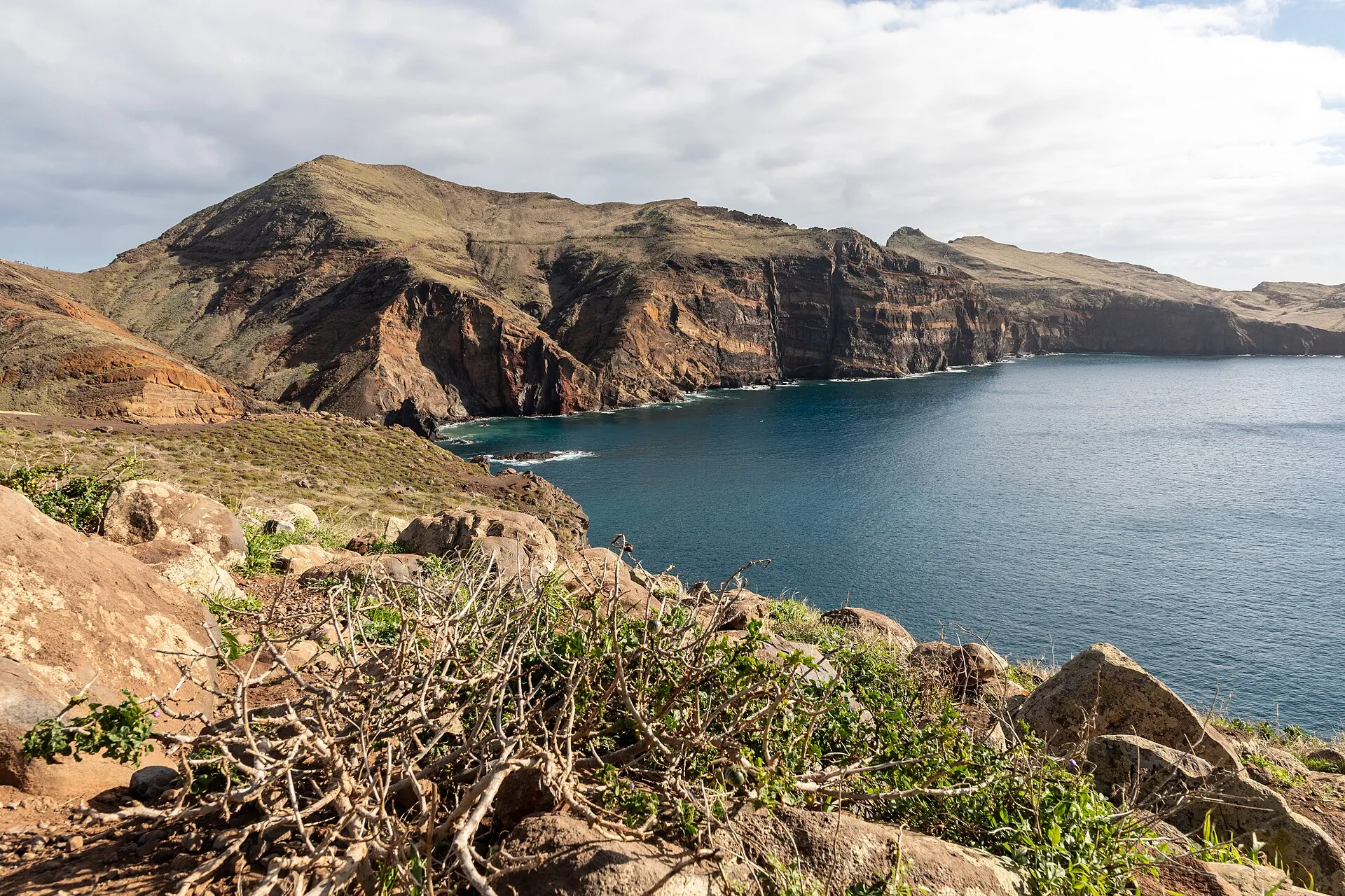
- East: sunrise on the high peaks, laurel forest at Ribeiro Frio, the thatched houses of Santana, the dry tip at Ponta de São Lourenço. Best on a clear morning.
- Decide on the morning, not at home. Look at a live webcam of Pico do Areeiro.
- Never both in one day. From the eastern tip to Porto Moniz is well over an hour of driving each way before you stop anywhere.
What “west” and “east” mean here
Funchal sits in the middle of the south coast and splits the island. Head out past Câmara de Lobos and you are going west. Head out past the airport and you are going east.
The mountains in the centre are closer to the east in practice. You reach Pico do Areeiro, Ribeiro Frio and Santana on the same kind of day as the eastern tip, so they are counted with it here. The north coast is split too: from São Vicente westwards is part of a western day, from São Vicente eastwards part of an eastern one.
The two sides compared
| West | East | |
|---|---|---|
| Signature sights | Cabo Girão, Rabaçal, Ponta do Pargo, Porto Moniz | Pico do Areeiro, Balcões, Santana, Ponta de São Lourenço |
| Landscape | Terraces, cliffs, forest plateau, lava coast | High peaks, laurel forest, bare volcanic tip |
| Swimming | Lava pools, Calheta’s sand beach, Seixal | Prainha’s black sand, Machico, Porto da Cruz sea pool |
| Paid entry | Cabo Girão €5 (non-residents, 2026), Porto Moniz pools €3 | Trail licences, Queimadas parking |
| Weather | Sunniest coast; high plateau often foggy | Peaks clear early, cloudy later; tip dry and windy |
| Best time of day | Flexible; Ponta do Pargo at sunset | Early. The peaks go by late morning |
| Driving | Longer distances, steep drops to villages | Shorter, simpler roads |
| Crowds | Rabaçal and Porto Moniz busy by late morning | Areeiro busy at dawn, São Lourenço by mid-morning |
| Walks | 25 Fontes, Risco, Fanal | PR 1 ridge, Balcões, São Lourenço, Caldeirão Verde |
Why the west is the safer bet
Most of the west’s best stops sit on the coast, below the cloud line. That is the whole argument. On a morning when the peaks are hidden, a western day loses very little: Ponta do Sol, tucked behind two headlands, is often in sun while Funchal is grey, and Porto Moniz swims whatever the plateau is doing.
It also has more kinds of thing in one day. A sea cliff at Cabo Girão, terraces cut by hand over five centuries, two villages at the foot of the cliffs that had no road until this century, a lighthouse at the end of the land at Ponta do Pargo, a cable car often called the steepest in Europe at Achadas da Cruz, and the lava pools at Porto Moniz.
What goes wrong in the west: trying to cram in Rabaçal as well. The walks there take a morning on their own, the car park on the ER 105 fills early, and since January 2024 the road over from Encumeada has been closed, so from Funchal you go the long way, up from Arco da Calheta. Choose: walking west or driving west.
A western day
Take the best of The West Coast from Câmara de Lobos to Paul do Mar in the morning. Climb to Ponta do Pargo and follow The Far West round to Porto Moniz for a late swim. Come back through São Vicente and the tunnel. Each of those tours could fill its own day, so choose your stops: the roads alone come to about three hours. If you have a second western day, spend it on Rabaçal’s Levada do Risco and 25 Fontes in the morning and the north-west coast, Seixal and the Véu da Noiva, in the afternoon.
Why the east is worth waiting for
When the peaks are clear, the east is the most dramatic day on the island. You drive to 1,818 m at Pico do Areeiro and stand above the cloud. You walk into the laurel forest at Ribeiro Frio and out onto the Balcões platform facing the ridges you just left. Then you go down to the coast and out to a peninsula of red rock with no trees at all.
It is also the easier drive. Distances are short, and the main roads to the peaks and the tip are good.
What goes wrong in the east: the order. The peaks are usually clear early and in cloud by late morning. The tip is hot and shadeless by midday. You cannot be at both at the right time on the same day, so pick which one gets the morning.
An eastern day
If the summit webcam is clear: Areeiro at dawn, Balcões by ten, lunch at Ribeiro Frio, then over to Santana and along the eastern end of The Wild North Coast through Faial and Porto da Cruz to the pass at Portela, and down to Funchal in about 35 minutes.
If the summit is grey: The Eastern Edge and Ponta de São Lourenço first thing, when the tip is still cool, then a swim at Prainha or Machico. Try the mountain again tomorrow.
Can you do both in one day?
People try, usually with a hire car and an early flight home. You can physically drive from the eastern tip to Porto Moniz and back in a day, thanks to the expressway and the tunnels. What you cannot do is stop anywhere long enough to enjoy it. You would spend three hours or more behind the wheel before stopping anywhere, and see each place through the windscreen. If you only have one day, choose a side. If you have two, give one to each.
Where to stay for each side
Funchal works for both. The expressway along the south coast puts both ends of the island within a day trip, and you come home to the same bed.
If the west is your priority, a couple of nights around Calheta or Ponta do Sol cut the drives and put you close to the sunset at Ponta do Pargo. If the east is your priority, Funchal or Caniço puts you close to the Areeiro road and the tip. Santana on the north coast is good for Pico Ruivo at dawn from Achada do Teixeira and for the Caldeirão Verde, but wetter and further from everything else.
Does the choice change without a car?
Yes. Buses reach the east more easily: the old line 113 (numbered 702 since March 2026) runs out to Baía d’Abra for Ponta de São Lourenço, and some runs of the Santana lines, the old 56 and 103 (now 801 and 850/860), cross the mountain via Ribeiro Frio. A Horários do Funchal bus climbs to Pico do Areeiro twice a day (06:00 and 13:30 from the cable car station on the summer timetable, €3 a trip in 2026). In the west there is no practical bus to Rabaçal or around the far corner. Without a car, the realistic choice is the east by bus or either side by taxi or organised tour. With one, the webcam decides, and driving in Madeira is worth reading before you pick up the keys.
If you drive, our tours of either side play in the car as you go, with the route stored offline for the valleys with no signal.
Questions people ask
Is the west or east of Madeira better?
It depends on the morning. With a clear summit, the east gives you the best views on the island. With cloud on top, the west is the safer day: more places to swim and more low, sunny coast to fall back on.
Can I see west and east Madeira in one day?
You can drive both, but most of the day goes on tunnels and hairpins. Give each side its own day and you see twice as much.
Which side of Madeira has better weather?
The south-west, around Ponta do Sol and Calheta, is often in sun when Funchal is not. The eastern tip is the driest. The high centre and the north coast are the cloudiest and wettest.
Where is the border between east and west Madeira?
Funchal. Anything you reach by heading out of the city towards the airport is east; towards Câmara de Lobos and Calheta is west. The mountains in the middle are usually counted with the east because you reach them on the same kind of day.
Is it easier to drive in the east or the west?
The east. The distances are shorter and the main roads to the peaks and the tip are well made. The west has longer drives, steep side roads down to the coastal villages and the busiest car parks at Rabaçal.