Madeira is a Portuguese island in the Atlantic Ocean, about 1,000 km south-west of Lisbon and roughly 700 km west of the Moroccan coast, north of the Canary Islands. It is the top of a volcano, steep on every side, with peaks above 1,800 m. That mountain in the middle of a warm ocean explains almost everything about its weather: mild all year, dry and sunny in the south, wet and green in the north, cool and cloudy on top.
In short
- Portugal and the EU, on the African plate. Euro, Schengen, and the same clock as London.
- The island is small (about 57 by 22 km) but very high, and the height shapes the weather.
- The south coast is sunny and dry, the north is green and wet, the peaks are about 10 °C cooler.
- The sea stays between roughly 18 and 24 °C all year.
- Porto Santo, the sandy neighbour, is a separate island with a completely different landscape.
Where Madeira is on the map
Madeira sits at about 32.7° north and 16.9° west. That is further south than any part of mainland Europe, level with Casablanca and Bermuda.
| From Funchal to | Distance (about) | Flight time (about) |
|---|---|---|
| Lisbon | 975 km | 1 h 45 |
| Porto | 1,200 km | 1 h 50 |
| The Moroccan coast | 700 km | Check current routes |
| Tenerife (Canary Islands) | 470 km | Check current routes |
| London | 2,450 km | 4 h |
| Frankfurt | 2,850 km | 4 h 15 |
Almost everyone arrives by air, at the airport near Santa Cruz, about 20 minutes east of Funchal. Part of the runway stands over the sea on columns, and the airport is known for its crosswinds. Our page on the airport and the wind explains what that means for your flight.
Madeira keeps the same time as the UK and Lisbon and changes the clocks on the same dates. It is an hour behind mainland Spain, France and Germany, which catches people out when they book a transfer.
Three climates on one island
The quickest way to understand Madeira’s weather is to split the island in three.
| South coast | North coast | Mountains | |
|---|---|---|---|
| Where | Funchal, Câmara de Lobos, Ponta do Sol, Calheta, Machico | Porto Moniz, São Vicente, Santana, Porto da Cruz | Pico do Arieiro, Paul da Serra, Fanal, Encumeada |
| Sun | The most | Much less | Often above or inside the cloud |
| Rain | Least | A lot more | Most of all |
| Temperature | Warmest | A few degrees cooler | About 10 °C cooler than Funchal |
| Looks like | Terraces, bananas, towns | Green cliffs, waterfalls, forest | Moor, rock, heather, fog |
The dividing line is the ridge of peaks down the middle. For much of the year a damp wind blows from the north-east. It meets the north side of the island first, is forced upwards, cools, and drops its moisture as cloud and rain on the north coast and the summits. By the time the air comes down the south side it is drier and clearer, and Funchal sits in that shelter.
Smaller features make their own weather too. Ponta do Sol, tucked between two headlands on the south-west coast, often has sun when Funchal does not. The far west can be clear while the east is grey. Half an hour in the car often changes the day completely.
Why it stays mild
It is a long way south. The sun is strong and the winters are short.
It is surrounded by ocean. Water warms and cools slowly, and there are hundreds of kilometres of it in every direction. In Funchal, the average temperature of the warmest month, August, is only about 7 °C above the coolest, February.
The wind and the current keep summer in check. The water flowing past is the Canary Current, the cooler, southward-flowing arm of the great clockwise loop of the North Atlantic that the Gulf Stream also belongs to. Together with the north-east winds, it keeps the sea and the summers cooler than you would expect this far south. Madeira only gets properly hot on the few days a year when a wind blows in from the Sahara.
Where the rain falls, and why the levadas exist
Funchal gets about 575 mm of rain in an average year, on around 53 days, most of it between October and March. The high central ridge gets several times as much. So the island always had water where people could not farm (the wet, steep north and the mountains) and farmland where there was not enough water (the sunny south).
The answer, from the 15th century onwards, was the levadas: narrow channels cut along the contours of the mountains to carry water from the wet side to the dry side. There are more than 2,000 km of them, and they still water the terraces. The paths built beside them for maintenance are the walks that bring most visitors here.
The same geography has a darker side. Heavy rain on steep slopes brings rockfall and, now and then, floods. On 20 February 2010, flash floods and mudslides swept through Funchal and Ribeira Brava and killed more than 40 people. It is why trails close after storms and why you should never walk a levada in heavy rain.
The sea
The water is cool rather than tropical: about 18 °C at its coolest, from February to April, and 23 to 24 °C in late summer. The coast is rocky and the Atlantic swell can be heavy, especially on the north and west in winter. That is why people swim in lava pools and sheltered bays rather than off open beaches. The pools at Porto Moniz and Seixal, filled and emptied by the waves, are the classic example. Porto Santo, lower and sandier, usually feels warmer and calmer.
The shape of the island
Madeira is the top of a huge volcanic mountain that rises from an ocean floor close to 4,000 metres down to more than 1,800 metres above the sea. Most of what you see was built over the last few million years; Porto Santo is far older. The most recent eruptions were about 6,500 years ago, and nothing is active today.
Rain and landslides have since cut deep valleys into the old volcano, so the island is almost all slope:
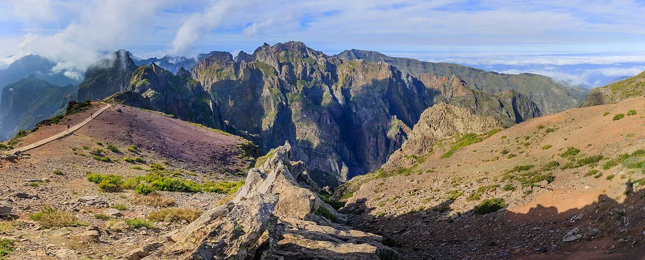
- A central ridge of peaks. Pico Ruivo is the highest at 1,862 m. Pico do Arieiro, at 1,818 m, is the one you can drive to.
- A high plateau. Paul da Serra, in the west, is a flat moor at around 1,500 m, the only large level area on the island.
- Sea cliffs. The coast drops straight into the sea in most places. Cabo Girão, west of Funchal, is about 580 m high.
- Very little sand. The beaches are mostly pebbles and rock.
This is why the map misleads. A 20 km trip can mean climbing 1,000 metres and coming down again, and before the tunnels many villages were hours apart.
Height also sorts what grows where. Bananas cover the lowest south-facing terraces, vines for Madeira wine and vegetable plots come above them, then pine and eucalyptus, then the heather and moor of the peaks. On the damp northern slopes grows the Laurisilva, a laurel forest of a kind that covered much of southern Europe millions of years ago and survived here because the ocean spared the island the worst of the ice ages. It is on the UNESCO World Heritage list and covers around a fifth of the island. The walk at Fanal, among old twisted til trees in the fog, gives you the feel of it.
The archipelago, and who lives here
Madeira the island is one of four groups of islands in the region:
- Madeira, about 741 km², where nearly everyone lives.
- Porto Santo, to the north-east: low, dry, with a golden sand beach around 9 km long. It has its own small airport, and the ferry from Funchal normally takes about 2h15 (about 3h15 in autumn 2026, for technical reasons).
- The Desertas, three long, bare islands you can see from the south-east coast on a clear day. They are a nature reserve and one of the last homes of the Mediterranean monk seal. Boat trips go out in calm weather.
- The Selvagens, about 300 km south of Funchal and closer to the Canaries than to Madeira: tiny, protected, and lived on only by nature reserve wardens and visiting scientists.
About 250,000 people live in the region (2021 census), around 105,000 of them in Funchal. Since 1976 Madeira has been an autonomous region of Portugal with its own government and parliament. For a visitor that changes very little: it is Portugal, in the EU, using the euro, and in the Schengen area. The practical details are on The practical things, and what to pack for three climates in one suitcase is on Weather and what to pack.
The Tropi Guide app’s road tours explain the landscape as you drive through it, from the terraces of the south-west to the forest of the north.
Questions people ask
Is Madeira in Europe or Africa?
Politically, Europe: it is an autonomous region of Portugal and part of the EU, using the euro. Geographically it sits on the African plate, much closer to Morocco than to Lisbon.
How far is Madeira from mainland Portugal?
About 1,000 km south-west of Lisbon, a flight of roughly 1 hour 45 minutes. Almost everyone arrives by air.
What time zone is Madeira in?
The same as London and Lisbon: Western European Time, with summer time on the same dates as the rest of the EU. It is one hour behind mainland Spain and most of western Europe.
Why is Madeira's climate so mild?
It is far south, at roughly the latitude of Casablanca, and surrounded by open ocean that evens out the seasons. Steady north-east winds and the cool Canary Current keep the summers from getting hot.
Why is the north of Madeira so much wetter than the south?
The prevailing wind comes from the north-east and hits the mountains first. The air rises, cools and drops its moisture on the north side and the peaks. By the time it reaches Funchal, most of the rain is gone.